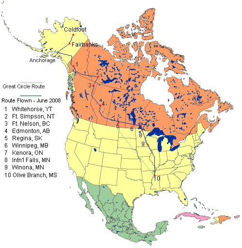
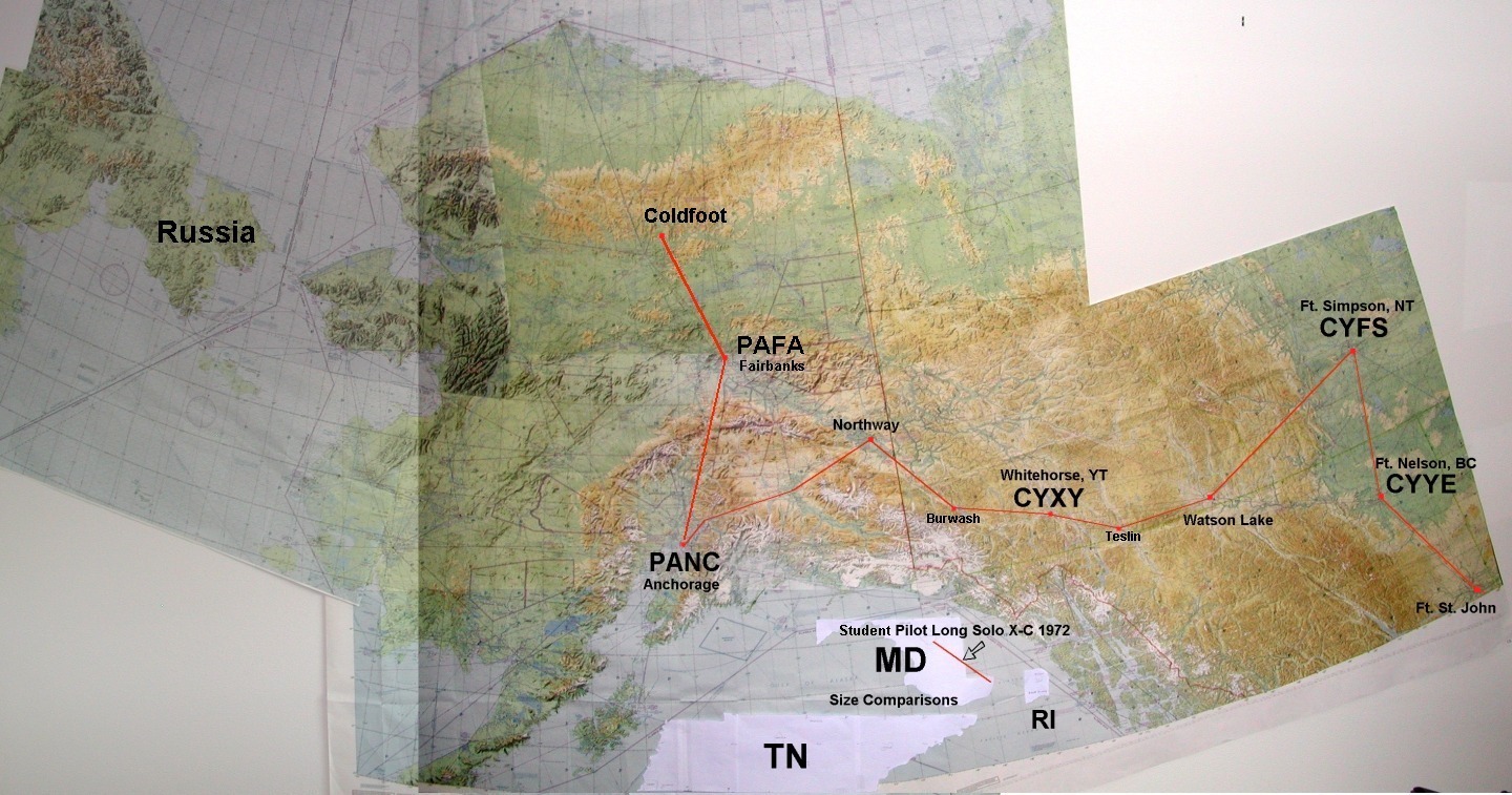
Routes flown in June, 2008
Mustang II Alaska Journal - 2008
Experimental Airplane - N727RH

Updated July 7, 2008
WARNING: Proper flight planning and preparation is required for all flights to and in Alaska.
Attempting to fly this route or duplicate this trip would obviously be AT YOUR OWN RISK.


Slew to: Flight South - "Alaska to The Lower 48" (on this page)

Go to: Planned Flight and Route - Alaska 2008 - Arctic Circle Flight- Flight to Seward
Alaska 2007 - Alaska 2006 - Alaska 2005 - Alaska 2002 - Equipment
ExperimentalAirplane.com Home

Journal

Spring, 2008
- Decided to take the Mustang II back south to TN / MS this summer.  This will be the third return, or sixth time to fly The Alaska Highway in the Mustang II, having flown it north on it's third trip to Alaska in May, 2006. It's been based in Alaska since that time.
- Feel delinquent in not making and posting a Journal for that trip, so getting started early on this one.

May 26
- Flew to Seward with coworkers flying in formation taking pictures.  Web page and photos

June 9
- Bought all new charts, both VFR and IFR for the route south: $325.

June 10
- Called a couple FBOs in Canada to get a feel for the fuel prices: $1.86 CDN per liter (~$6.85 USD / gal.) in Edmonton; $2.14 CDN per liter (~$7.85 USD / gal.) in Whitehorse.
- For future comparison, this week in Anchorage Regular auto fuel is $4.19 ; Avgas $5.86 ; Oil $135 / barrel.

June 13
- Planned the route again, adding stops in The Northwest Territories (Ft. Simpson), Manitoba (Winnipeg) and Ontario (Kenora).
- Estimated mileage: 3360 NM, ETE: 23 hours
- This will add three Canadian Provinces to the Mustang II's "collection", having been to only five so far: (YT, BC, AB, SK, QB)
- Brief consideration was given to also going to Nunavut, but I decided that is too far out of the way for this trip.
- Possibly a visit to the Maritime Provinces will occur in the future.

June 14
- Added planned route to the web site
- Planning to depart about June 23rd, expecting three to four days enroute, weather permitting.
- Our family: Tim, Gennie, Matt and Noah flew in to Anchorage for a week-long visit.

June 18 Black Bear at Eagle River Nature Center
- Went to Eagle River Nature Center with the family, and while eating lunch on the deck there, a black bear joined us. As we sat at the picnic table, Matt, sitting across from me suddenly was wide-eyed looking at my left ear and said "Holy s*#&!"  Thinking it was a huge mosquito, I swatted my ear, turned slightly, but didn't see or feel anything. I said "What?" He said "You've got to be kidding me - LOOK!" as he stood up pointing at the bear walking toward us 25 feet behind me. Tim & Gennie grabbed the baby and Linda grabbed the food, briskly moving away. Matt and I grabbed our cameras. The bear was just looking for food, and wandered around the Nature Center deck area. It got a bit more exciting when it knocked in a screen to one of the Nature Center windows and started to climb in. Someone fought the bear away from the window by hitting it with the screen. It wandered away a few minutes later.
- It was a highlight of our kids' visit, to say the least.

June 19-20
- Flight with Matt to Coldfoot, Alaska, crossing the Arctic Circle at midnight. Web page and photos
- We watched the sunset today - the Summer Solstice - at 11:42 PM in Anchorage. We pay a lot of attention to the solstices in Alaska.  The funny thing is, some actually feel a slight twinge of depression, since now for the next six months the days start getting shorter.

June 22 - Sunday
- Woke up to pouring rain and 20K+ winds in ANC. Review of the weather prog charts tells me that the weather analysis / 'when-to-go' decision is going to be a bit tricky.
- Packed all gear in the airplane in anticipation of an adequate weather 'window' tomorrow. If it's marginal, I may have to stop at Northway on the way to Whitehorse.
- Linda will occasionally post my progress to the Mustang Group while I'm away from any internet access.
- Tracking via http://flightaware.com/live/flight/N727RH should be possible, (use Flight/Tail #: N727RH), although it gets sketchy when in the non-radar environment from 50 NE of ANC to Edmonton, which will be about 2 days / 11 hours of flying away.
- Screen prints would be appreciated, and can be emailed to: rick@experimentalairplane.com. Thank you in advance!
- This Journal probably won't be updated very frequently, or at all while in transit.


Alaska to The Lower 48
including stops in seven Canadian Provinces

June 23 - Monday
WAC Charts of Alaska and northwest Canada showing routes flown
Day 1
Anchorage, Alaska - Whitehorse, Yukon Territory - Ft. Simpson, Northwest Territories


- Beautiful calm morning in Anchorage, but fairly low IFR in Whitehorse, marginal in Northway.
- (0600 ADT) Deciding how to proceed...
- (0700 ADT) Decided to try non-stop to Whitehorse. 600' ceilings and headwinds are forecast, so may need to drop in to Northway.
- Planned T/O time 1700 Z / 0900 ADT, called CAN-PASS with an ETA of 1415 PT.

- Started up at 0853 leaving the nice Lake Hood hangar that was 'home' since November and taxied the two miles to runway 25R at intersection E at Anchorage International. Was willing to depart the Lake Hood gravel strip, but ATC couldn't approve an IFR departure from there. Departed Anchorage IFR at 0909 ADT. Although the ATIS said "Few at 2,200'; ceiling 5,500' Broken", taking off to the west over the Cook Inlet I went into the clouds at 800' after takeoff. Broke out at 3,000', and as ATC turned me northward, saw Mt Susitna / 'Sleeping Lady' to the west partially under a white blanket. To the east were the tops of the Chugach Mountains and 120 miles to the northwest was Mt. McKinley. About 50 miles northeast of Anchorage, Center announced: "Radar Service is terminated". OK, I'll be "on my own" for the next 1,100 miles of wilderness flying. Looking southeast the Chugach Mountains were very pretty poking through the clouds. Ten minutes later at 0958 I passed the Matanuska Glacier as the cloud deck lowered to my altitude of 11,000'. This would be the last I saw of the ground until arriving at Whitehorse three hours and twenty minutes later.

- The flight was 4+10, the last three plus hours were solid IMC (Instrument Meteorological Conditions), flown at 11,000' - the eastbound MEA [IFR Minimum Enroute Altitude]. I picked up a trace of ice and requested a climb to 13,000' then 15,000' (on oxygen) thinking I might be able to top the clouds since I could see the sun dimly above, but that 'didn't work out', so descended back to 11,000' for the rest of the flight. My instrument scan included frequently turning around to check the black vinyl tape "ice detector strip" I have on the horizontal stabilizer. I must've turned around every 90 seconds for the next three hours. I kept myself busy plotting my GPS position on the visual charts - in case I'd be descending - and with getting weather updates for possible enroute alternates - which were my 'out' if the icing condition should worsen. When I was within range of Gulkana, Northway, Beaver Creek and Burwash, I had the Instrument Approach plates out and studied them. As I'd seen on the satellite chart a few hours earlier the clouds were fairly consistent stratiform, so the trace of ice remained but never got any worse.

- Flew the non-radar LOC BC / NDB / DME approach with a DME arc to 13R, seeing the runway in the rain at the MDA, landing at 2119 Z / 1419 PDT. This was a "piece of cake" compared to the last time I did this approach under similar weather conditions in 2005 when I was on partial panel due to a vacuum pump failure. Customs met me at the plane, and after a few questions we were done in a few minutes. Nice. He did seem surprised that such a small plane could fly non-stop from Anchorage. Got lunch at the terminal and then an effective, quality in-person weather briefing from NavCanada for the next leg. There was no time wasted telling me about "unlighted towers 100' AGL 10 miles from the airport...".

- Departed Whitehorse at 2314 Z / 1614 PDT IFR to Ft. Simpson, Northwest Territories. After climbing through the lower cloud layers near the airport, the next thirty minutes of flight was with just scattered clouds around, yielding a nice view of Teslin Lake and Airport. Fifteen minutes later at 0000 Z over the Cassiar Mountains I took a "panorama" series of photos [#1] , [#2] attempting to capture the stark, desolate wilderness of the Yukon - even in June, and then suddenly went into solid cloud again - for the next hour and 45 minutes. Again, most of the flight was IMC [Instrument Meteorological Conditions]. It's always an issue dealing with ice - even in the summer at the Minimum Enroute IFR altitudes, which on this leg was 9,000'. The entire 2+49 flight was non-radar, with only one position report at 0027 Z over Watson Lake through Whitehorse Radio to be relayed to Edmonton Center - much like the DC-3's of the early US airlines did in the 1940s and 50's. The 242 NM / 1+30 NDB airway leg from Watson Lake to Ft. Simpson - flying away from The Alaska Highway - had no radio communication, and was probably the loneliest, most wilderness stretch I'd ever flown in the Mustang. Throw in some ice buildup over the very rugged mountains below (that I couldn't see) made it, well, "interesting". (Didn't want to say 'scary'...)  As on the previous leg, I kept myself busy plotting my GPS position on the visual charts, but there were no enroute alternate airports except Ft. Nelson, 160 NM / 1 hour to the southeast.  (See the full-size WAC charts image showing the route.)

- Weather cleared nicely approaching the Ft. Simpson airport, and did a visual approach to runway 31, landing at 0203 Z /2003 MDT. I think the CARS [Community Aerodrome Radio Station] operator was surprised by my arrival. When I called in, he said: "You're landing HERE?" Tied down for the night while fending off numerous large black flies. The town of Ft. Simpson is a major access point to the Northwest Territories with a population of 1200, approx. 90% of whom are "First Nations" (Native Americans). The Liard and Mackenzie rivers come together here among lots of beautiful trees. Spent the 'night' at the Nahanni Inn - it was light all night with sunset at 11:55 PM MDT.

FromToFlightBlockAirway
N. Miles
PANC
Anchorage, AK
CYXY
Whitehorse, YT
4+104+27518
CYXY
Whitehorse, YT
CYFS
Ft. Simpson, NT
2+493+08441
Total for Day 16+597+35959
Flight Tracks: PANC-CYXY, CYXY-CYFS (non-radar)


June 24 - Tuesday Weather approaching Regina airport
Day 2
Ft. Simpson, Northwest Territories - Ft. Nelson, British Columbia - Edmonton, Alberta - Regina, Saskatchewan


- Fueling was going to be a hassle and extra expensive ($50 call-out charge), so decided to go with the 25 gallons I had on board to Ft. Nelson, altering my plan slightly. On the ride to the airport leaving town a sign along the road said: "Edmonton 1443 KM". That sounded like a long way, which I would attempt today.   Departed Ft. Simpson at 1457 Z / 0857 MDT, flying VFR to Ft. Nelson. Incredibly clear and smooth with the Franklin Mountains visible 60 miles to the northwest. I watched the GPS count down to 60° North - the border between The Northwest Territories and British Columbia, and as I crossed it, saw several cutlines in the trees. It was intriguing enough for me to do a 360° turn and try to get a picture of it.   It appears that the surveyors have adjusted their calculations over the years.  On the image, I've indicated the cutline which lined up best with 60° on the GPS.   I'm going to send a copy to my 4th grade geography teacher who taught us that "The lines on maps aren't really on the ground".

- Landed at Ft. Nelson at 1614 Z / 0914 PDT, refueled and departed IFR at 1717 Z for Edmonton City Centre. It felt really good to hear "Radar Identified" 20 miles north of Ft. St. John at 1817 Z. No longer in the "Sparsely Settled Region", I took off my survival vest and relaxed a bit. Was cleared direct from Edmonton Center, but had to deviate south slightly to avoid some buildups between Grand Prairie and Whitecourt. Landed at Edmonton City Centre airport at 2023 Z / 1423 MDT. Studied the weather at the FBO, which was an issue trying to go to Saskatoon.

- A Low Pressure area with thunderstorms was in Saskatchewan, and after studying it a while with NavCanada's assistance, decided to route myself south from Edmonton, passing the International Airport then gradually turn southeast and try to get to Regina instead. Took off of Edmonton at 2210 Z / 1610 MDT deviating west of the thunderstorms that were in Alberta and Saskatchewan. That worked out fairly well, however upon arrival at Regina, there was heavy weather west, north and east of the airport. ATC assisted by suggesting vectors to come into the airport from the southwest. I had an "out" by heading back south and could have diverted to Moose Jaw or Swift Current if necessary. For the landing on runway 31, the tower called the winds as 350° @ 21 gusting to 28.  Landed at Regina at 0102 Z / 1902 CST (Saskatchewan doesn't observe Daylight Savings Time). Today was a bit of a brain-teaser keeping the local time zones straight - going from MDT then 'backwards' to PDT back to MDT to CST (which wasn't a change?!)

- It started to POUR as I got to the Shell AeroCentre ramp. The guys there said the hangar that we were in front of was available - that was a "no-brainer". Although we got it into the hangar in about 3 minutes, we still got soaked. I did a 'poor-man's plane wash' by wiping the plane down with a chamois, and a half-hour later the skies cleared up soon becoming a clear, pleasant evening in Regina. Spent the night at the West Harvest Inn which was very nice. It was a bit strange having a dark night for the first time in a while...

FromToFlightBlockAirway
N. Miles
CYFS
Ft. Simpson, NT
CYYE
Ft. Nelson, BC
1+171+25185
CYYE
Ft. Nelson, BC
CYXD
Edmonton, AB
3+063+12476
CYXD
Edmonton, AB
CYQR
Regina, SK
2+523+06450 (est.)
Total for Day 27+157+431111
Total for Trip14+1415+182070
Flight Tracks: CYYE-CYXD (1), CYYE-CYXD (2)
CYXD-CYQR (1), CYXD-CYQR (2), CYXD-CYQR (3)


June 25 - Wednesday Winona, Minnesota
Day 3
Regina, Saskatchewan - Winnipeg, Manitoba - Kenora, Ontario - to Winona, Minnesota


- A clear day in Saskatchewan. Talked to a Canadian Forces Instructor Pilot that was also about to depart, and got a quick view of the Harvard trainer and its cockpit.  It looked like it would be a lot of fun to fly!  Departed at 1539 Z / 0939 CST IFR for St. Andrews airport in Winnipeg, Manitoba, landing 1+51 later at 1730 Z / 1230 CDT. Got lunch at this nice General Aviation airport where a fair amount of flight training was taking place.  Called US Customs in International Falls giving them my ETA of 1615.

- Departed St. Andrews at 1342 and landed at Kenora, Ontario at 1426.  Arriving here accomplished the goal for this trip: this Mustang II has now been to eight Canadian Provinces - seven this week plus Québec back in 2003.  Kenora looks like a great vacation area with numerous lakes around. Several "heavy iron" bizjets were on the ramp, folks probably also on vacation.  Gave US Customs at International Falls a revised ETA of 4 PM and departed Kenora at 1510 expecting 45 minutes enroute.  Passed the Lake of the Woods in the extreme southwestern corner of Ontario trying to find the "notch" of Minnesota that sticks up into Canada.

- Real nice tailwinds made the GPS ETA show my arriving way too early and Customs doesn't like it if your estimate is not within 15 minutes, so I needed to pull the Mustang's speed way back to kill some time.  Still had a 160 K groundspeed with the power back at 5 gallons per hour. It was strange - for the first time the Mustang's high speed was a problem.  Flying in slow flight for the last several miles prior to crossing the Rainy River - the boundary between Canada and the US, I entered downwind for runway 31 and landed at 1546, blocking in at the designated Customs Circle at 1548.  The Customs visit was pretty routine and I never even needed to get out of the cockpit until after the inspector left.

- Decided to fly another couple hours, so filed to Winona, Minnesota.   Took off from International Falls at 1650, passed Duluth, MN, needed to do some minor cumulus deviations enroute and landed at Winona at 1840.

- Winona is the birthplace of Max Conrad with the airport named in his honor. He set incredible distance records in light airplanes in the 1950's and 60's and has been a very inspiring pilot to me.  For example, in 1959 he flew a single engine Comanche non-stop for 58+38 hours from Casablanca, Morocco, Africa 7668 miles to Los Angeles.   In 1964 he flew a Twin Comanche non-stop from Capetown, South Africa to St. Petersburg, Florida, 7878 miles in 55(?) hours.   That record for that Class airplane held until the flight of Rutan's Voyager around-the-world in 1986.   His biography "Into The Wind" was written by Sally Buegeleisen, who with her husband were the original owners of N7766Y, the Twin Comanche that I bought in 1991.   Max flew 66Y a bit while she was writing his biography, and it seemed fitting to visit the airport named in his honor.   Especially since my Mustang's engine was the right engine from 66Y.   Hmmm... I just now realize that engine I was flying over that inhospitable terrain in Alaska and the Yukon is 44 years old! (Overhauled by Mattituck in 1994, though.)   His long-distance flights inspired me to build the Mustang II with long-range capabilities and to also fly the long-range MD-11 at work.

- Parked in the grass, talked to the FBO manager a bit about Max Conrad reviewing the memorial display about him and then called it a night.  Plan for tomorrow: Weather permitting, a 595 NM, four hour non-stop flight [of course!] to Olive Branch, MS.

FromToFlightBlockAirway
N. Miles
CYQR
Regina, SK
CYAV
Winnipeg, MB
1+512+09298
CYAV
Winnipeg, MB
CYQK
Kenora, ON
0+440+55103
CYQK
Kenora, ON
KINL
Intn'l Falls, MN
0+360+4384
KINL
Intn'l Falls, MN
KONA
Winona, MN
1+501+57288
Total for Day 35+015+44773
Total for Trip19+1521+022,843
Flight Tracks: CYQR-CYAV, CYAV-CYQK, CYQK-KINL, KINL-KONA


June 26 - Thursday
Day 4
Winona, Minnesota - Olive Branch, Mississippi
Thunderstorms avoided

- A nice day in Winona, but a not-so-nice day in Iowa and Missouri. There was a large complex of thunderstorms that appeared might cut-off my next leg southbound.  Abandoned my plans to visit the Winona Historical Society this morning in order to get a jump on the weather. Probably one of the best tips I've ever read about avoiding thunderstorms and turbulence was from AOPA Pilot magazine that simply said: "Fly early and be on the ground by noon". That became today's plan.

- Arrived at the airport before the FBO opened and filed IFR to Olive Branch from a pay phone. I was planning that I may need to land in Peoria or Springfield, IL if things got more active.  Started up at 0815, off at 0824, picking up the clearance from Minneapolis Center shortly after takeoff.  The route filed worked out great, with excellent visibility, although I could see the higher clouds to the west where the convective weather was brewing.  Skies along the route continued to be clear as I passed Davenport, Iowa.  I peered below trying to see evidence of the recent flooding that the area has endured.

- At 1000 Springfield Approach gave me "Direct to OLV". Cool. That knocked 30 miles / :12 off of the remaining route, making the new GPS ETA 1158.  At 1045 I started second-guessing my decision to leave early and miss seeing the Max Conrad artifacts.  It's really strange how fate works, because within two minutes after that thought I suddenly hit moderate turbulence in the clear air.  I quickly said to myself; "Disregard that last thought..."  Climbed to 8,000', then 10,000' for a somewhat smoother ride and filed a PIREP (Pilot Report). Although I couldn't see it, there was significant convective activity to the west.

- Fifteen minutes later I was switched to Memphis Center.  Then received a clearance to "Cross 45 miles north of Olive Branch at 6,000'.  Wow - I'm almost there... Today's flight sure has seemed to go extra quickly.  On Memphis Approach I requested the straight-in GPS approach to 18 at Olive Branch, and flew the WAAS / LPV approach in visual conditions.  These LPV approaches really 'nail' the centerline - right at the thousand-foot marker of the runway.  When cleared to land, the wind was 250° at 14 gusting to 22 knots.  Very briefly I thought about going to Memphis and landing on runway 27, but decided to "give it a try".

- Landed at Olive Branch at 1203, shutting down in front of my hangar at 1207.  Unloaded all the gear from the plane, and paused for a minute listening to the 'tick-tick' sound of the engine cylinders cooling down reflecting on how far I'd travelled in this machine the last week. I'd gotten into a good routine each day, and seven hours or 1,000 NM per day felt 'just right'. For another moment I thought: "It's only noon - I could be in central Florida for dinner, Nassau for lunch tomorrow, and could even be in Puerto Rico the next day..."   Then some sweat dripped into my eye bringing me back to some sense of reality.  It was 85° and humid, 95° in the hangar... Oh, how I've become "Alaska-ized"... I'll go ahead and catch that company jumpseat back home to the cool weather in Anchorage tomorrow night!

- A big THANK YOU! to those who sent screen prints of the Flight Tracking.

- For those building, or dreaming of building your own Mustang II, "Keep Building !" - because as Kirk Harrell has said: "These machines are true Magic Carpets".

Rick Henry
June, 2008

FromToFlightBlockAirway
N. Miles
KONA
Winona, MN
KOLV
Olive Branch, MS
3+393+52565
Total for Day 43+393+52565
Total for Trip22+5424+543,408 NM
3,926 SM
Total including
Trip to Coldfoot
28+5631+474,240 NM
4,880 SM
Flight Tracks KONA-KOLV: Enroute, Landing, Flight Summary


Return to: Alaska 2008 - ExperimentalAirplane.com Home